Section #1 - The American Civil War: 1861-65
Chapter 18: The Shenandoah Valley Belongs to Stonewall Jackson
The Valley stretches some 200 miles from Harper’s Ferry in the southwest to Roanoke in the northeast. Its nearest point to Washington lies at Kernstown, a span of 80 miles. The Blue Ridge Mountains flank the Valley to the east while Opequon Creek runs along the west.
As such the Valley becomes a critical highway for the passage of Union and Confederate troops throughout the war.
In the Spring of 1862, General Stonewall Jackson launches his campaign to control the entire Shenandoah range, winning the final five battles over a host of outsmarted Union commanders.
Stonewall Jackson’s 1862 Battles in the Shenandoah Valley
| 1862 | Battle of | Victory | Union General | Union Troops / Casualties | CSA Troops / Casualties |
|---|---|---|---|---|---|
| March 23 | Kernstown | Union | Erastus Tyler | 7,700 – 590 K/W/M | 3,600 – 718 K/W/M |
| May 8 | McDowell | CSA | Robert Milroy | 6,250 – 257 | 7,500 – 516 |
| May 23 | Front Royal | CSA | John Kenly | 1,063 – 773 | 3,000 – 36 |
| May 25 | Winchester | CSA | Nathaniel Banks | 6,500 – 2,019 | 16,000 – 397 |
| June 8 | Cross Keys | CSA | John Fremont | 11,500 – 684 | 5,800 – 287 |
| June 9 | Port Republic | CSA | Erastus Tyler | 3,500 – 1,002 | 6,000 – 816 |
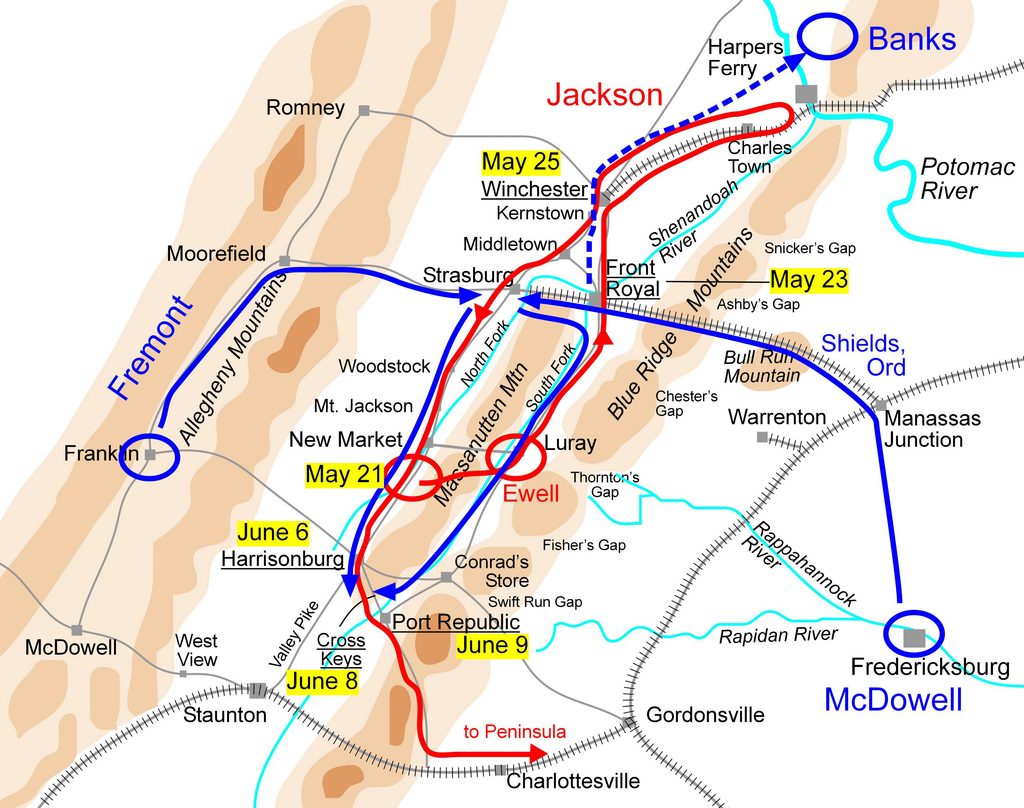
Map by Hal Jespersen, via Wikimedia Commons. Public domain