Section #8 - Our Modes Of Transportation
Our Modes of Transportation
You are there:
During its 500 years of global dominance (31BC-476AD), the Roman Empire builds some 250,000 miles worth of roads, aimed at establishing control over its conquered territories. Roads allow the legions to march, commerce to grow, and Roman law to govern. Included in the total are 2,000 miles laid down in Brittania, which the Romans occupy from 41AD to 410AD. These roads, covered with gravel or paved with concrete, are made to last and they do.
Roads
So the later day British colonists arrive in America well versed in the need for roads to populate and unify their new homeland. Their initial efforts are modest, paid for by limited local government funds, and confined to linking nearby settlements.
The need to deliver mail plays an important part in the more ambitious early projects. In 1650 King Charles II orders construction of a road connecting Charleston, South Carolina, with Boston, Massachusetts. This King’s Highway covers 975 miles and isn’t completed until 1730. Still it holds the distance record for mileage until 1806 when the Federal Road opens up.
Other sizable undertakings follow. The Fall Line Road stretches 500 miles from Fredericksburg, Virginia, south to Augusta, Georgia. In 1744 the Great Wagon Road runs southwest from Philadelphia down to Roanoke, Virginia, then branches off in two directions, one ending in Knoxville, Tennessee, the other in Augusts, Georgia. Despite its name, wagon travel is limited to only parts of the highway.
Also prior to the Revolutionary War the Boston Post Road links two important urban centers, Boston and the city to New York.
Important North-South Trails And Roads In The East
| Name | Opens | From | To | Distance |
| King’s Highway | 1650 | Boston | Charleston, SC | 975 |
| Upper Post Road | 1673 | Boston | New Haven, Conn | 135 |
| Lower Post Road | 1678 | Boston | Greenwich, Conn. | 180 |
| Albany Post Road | 1703 | New York City | Albany, NY | 150 |
| Fall Line Road | 1735 | Fredericksburg, Va | Augusta, Ga | 500 |
| Great Wagon/Valley Road | 1744 | Philadelphia, Pa | Knoxville, TN | 330 |
| Boston Post Road | 1772 | Boston | New York City | 215 |
The pioneer spirit which carries the colonists across the Atlantic is soon evident as the colonists look westward for more places to settle. But instead of having the Atlantic Ocean in their way, they are now confronted by the 1500 mile Appalachian mountain range, running from Canada to Georgia and providing a natural obstacle to inland travel.
To address this barrier, the Americans turn once again to the tribal trails in use for centuries.
The first milestone is the Mohawk/Iroquois Trail, which extends a native trade route in Massachusetts for an additional 288 miles across New York Colony from Albany to Buffalo. It is completed by 1664 and commerce begins.
Routes across Pennsylvania and from Virginia into Kentucky follow between 1755 and 1796.
Then comes the most ambitious East-West corridor of all, the Old Federal Road which runs from the new U.S. capital at Washington City all the way to New Orleans. Thomas Jefferson sets the project in motion in 1801 and the 1,085 mile route is completed in 1811 by elements of the 3rd U.S. Infantry.
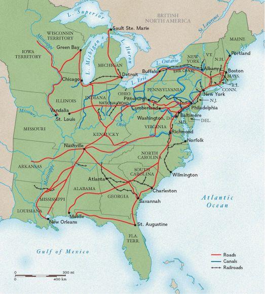
At first, development of roads is inhibited by the reluctance of Jefferson’s Democrat Party to use federal monies to pay for them. But as their importance to the economy becomes apparent, this changes. The National Road, running 615 miles from Cumberland, Maryland, to Vandalia, Illinois, becomes the first paid for with federal funds.
Important East-West Trails And Roads
| Name | Opens | From | To | Distance |
| Mohawk Trail in NY | 1664 | Albany, NY | Buffalo, NY | 288 |
| Allegheny Path | 1755 | Philadelphia | Pittsburgh | 305 |
| Braddock’s Road | 1755 | Cumberland, Md | Braddock, Pa | 95 |
| Pennsylvania Road | 1775 | Harrisburg, Pa | Pittsburgh, Pa. | 200 |
| Wilderness Road | 1775 | Bristol, Va. | Frankfort, Ky | 255 |
| Zane’s Trace | 1796 | Wheeling, WVa | Maysville, Ky | 230 |
| Old Federal Road | 1811 | Washington, DC | New Orleans, La | 1,085 |
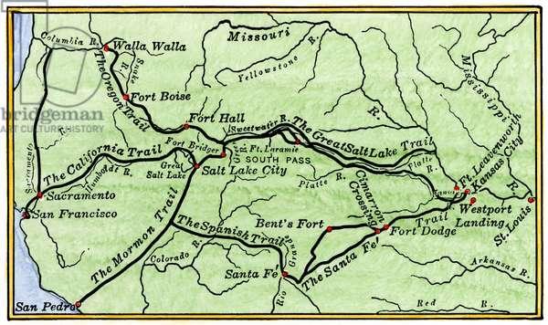
| Oregon Trail | 1811 | St. Louis, MO | Oregon City, OR | 2,170 |
| Santa Fe Trail | 1822 | Franklin, MO | Santa Fe, NM | 900 |
| Spanish Trail | 1829 | Santa Fe, New Mexico | Los Angeles, Ca. | 2,700 |
| National Road | 1835 | Cumberland, Md. | Vandalia, Illinois | 615 |
| Mormon Trail | 1846 | Nauvoo, IL | Salt lake City, Utah | 1,300 |
| California Trail | 1847 | Salt Lake City, Utah | San Francisco, Ca | 1,600 |
The condition of these major roads varies widely. Most remain dirt paths, albeit smoothed and widened by decades of use.
But some, however, are already being “macadamized,” according to construction guidelines developed by the Scotsman, John MacAdam, around 1815 in England. MacAdam’s idea is a simple one that involves laying a bed of finely crushed stones over a carefully leveled dirt path, slightly bowed in the center to facilitate the run-off of rain and snow.
The use of stones enables Macadamized roads to avoid the bane of travel along dirt paths, which easily turn into mud in the presence of rain.
As time passes, a cheaper alternative to the macadam construction materializes in the form of the plank road. Here lumber “sills” are laid down in parallel about six feet apart, and covered by wood planks that are eight foot long by three foot wide by four inch thick. These are placed perpendicular to the sills and held down by their own weight. Plank roads tend, however, to wear out every 4-5 years, and they eventually fade out of popularity.
The benefits of these new improved roads are so obvious that some become “turnpikes” – built by entrepreneurs who line them with “toll booths” to collect fees and turn a profit.
Turnpike Incorporations
| Period | # Filings |
| 1790-1800 | 69 |
| 1801-1810 | 398 |
| 1811-1820 | 362 |
| 1821-1830 | 230 |
| 1831-1840 | 365 |
In 1821 President Monroe proudly reports progress in the construction of “post roads” in his address to the Congress:
There is established by law 88,600 miles of post roads, on which the mail is now transported 85,700 miles, and contracts have been made for its transportation on all the established routes, with one or 2 exceptions. There are 5,240 post offices in the Union, and as many post masters.
At first, overland transportation is accomplished on foot or horseback and in carriages, carts or wagons pulled by various beasts of burden. In the 1840’s a dramatic new options will appear in the form of “Iron Horse” locomotives traveling along a new form of road – railroad tracks. (See below.)
Waterways
In addition to the construction of roads, America’s territorial expansion and economic growth also benefit from its waterways.
Its two great oceans provide major barriers to foreign invasions and also trade routes to Europe, Asia and the rest of the world. Its inland lakes and rivers support the arteries and veins needed to create a unified nation state.
Some rivers flow north and south, often defining, often transcending state borders.
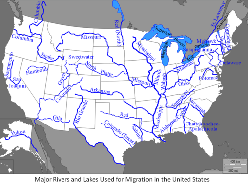
Major North-South Rivers
| Name | Miles | States |
| Mississippi | 2,340 | Minn to Louisiana |
| Colorado | 1,450 | Colorado to New Mexico |
| Red | 1,290 | New Mexico to Arkansas |
| Columbia | 1,243 | British Columbia to Oregon |
| Green | 730 | Utah to Wyoming |
| Sabine | 510 | Texas, Louisiana |
| Wabash | 503 | Indiana, Illinois, Ohio |
| Susquehanna | 464 | Maryland, Pennsylvania, NY |
| Connecticut | 419 | Connecticut, Vermont, NH, Vt |
| Potomac | 405 | Maryland |
| Alabama | 318 | Alabama, Georgia |
| Hudson | 315 | New York, New Jersey |
| St Johns | 310 | Florida |
| Savannah | 301 | South Carolina, Georgia |
| Pee Dee | 232 | South Carolina, North Carolina |
| Scioto | 231 | Ohio |
| Oconee | 220 | Georgia |
| Kennebec | 170 | Maine |
Others flow east and west, and play a crucial role in opening up the new states west of the Appalachian Mountain range. The longest eastern river, the Ohio, becomes the official line of demarcation in 1787 between the “free” states of the North and the “slave” states of the South.
Major East-West Rivers East Of The Mississippi
| Name | Miles | States |
| Missouri | 2,341 | Missouri to Montana |
| Rio Grande | 1,885 | Colorado to Gulf of Mexico |
| Arkansas | 1,469 | Arkansas to Colorado |
| Snake | 1,078 | Wyoming to Washington |
| Ohio | 981 | Pa, Ohio, WVa, Ky, IN, Illinois |
| North Platte | 716 | Nebraska to Colorado |
| Cumberland | 688 | Kentucky, Tennessee |
| Tennessee | 652 | Tennessee, Ala, Miss, Ky |
| James | 348 | Virginia |
To the north, across eastern Canada, the St. Lawrence River – Great Lakes system, runs 2,340 miles from the Atlantic coast to the tip of Lake Superior. This route will prove especially providential to the fur trade, which is booming by 1790.
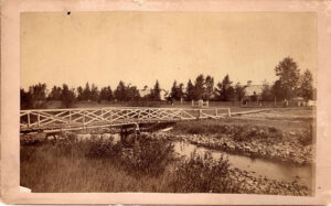
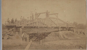
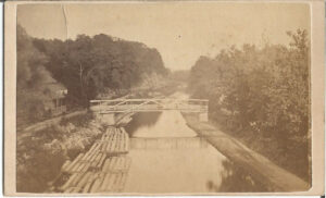
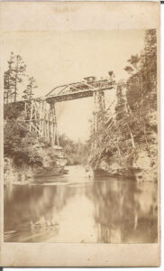
Where rivers are too broad to ford, bridges go up, often funded by corporations with the intent to reap profits from user fees. As with the turnpikes, “toll bridges” often anger cash strapped travelers and some are bankrupted by legal challenges – as in the Boston case of Charles River Bridge vs. Warren Bridge argued before the Supreme Court in 1837.
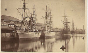
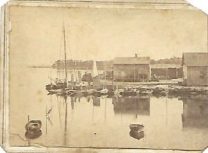
Those traveling by river use various means from dugout canoes, rowboats, rafts and barges to full-masted sailboats. Until steamboats appear, river currents either help or hinder progress.
Canals
While canals appear centuries before the Christian era in Mesopotamia and China, it is the engineer James Bridley who popularizes them in Britain around 1761.
Both George Washington and Gouvernor Morris express interest, and corporate charters are set up for several companies specializing in “navigational lock” construction. “Locks” are a necessary part of the canal building process. Their role is to enable barges or boats to pass through sharp rises or drops in land and river elevations (e.g. “falls or rapids”) without damage. They do this by “locking” the barge in a contained tank of water, which is then flooded or drained to allow it to rise or fall to a desired height, before an exit door opens to pass it along.
During Jefferson’s presidency talk begins about building a canal along the Mohawk River to help link the port of Buffalo on Lake Erie with the Hudson River leading down to New York City. The notion is deemed madness given the fact that land elevation drops some 600 feet between Buffalo to the west and Albany to the east. With each individual “lock” able to accommodate no more than a 12 foot change in water height, this means the canal will require construction of over 50 such individual stations – at a total cost deemed unaffordable by all who assess it.
But two men refuse to give up on the idea. One is Jesse Hawley, a flour merchant in Geneva, NY, who begins to calculate the cost savings the canal could deliver, especially to grain merchants in the Ohio valley. The other is the powerful politician, DeWitt Clinton, who serves as Mayor of New York City between 1803 and 1815, and barely loses out to Madison in the 1812 presidential election. Clinton sets up The Erie Canal Commission in 1810, and becomes a fierce and tireless supporter of the venture. His assessment of the project’s effects on the city will prove prescient.
The city will, in the course of time, become the granary of the world, the emporium of commerce, the seat of manufactures, the focus of great moneyed operations…and before the revolution of a century, the whole island of Manhattan, covered with inhabitants and replenished with a dense population, will constitute one vast city.
Despite opposition to “Clinton’s Folly,” he secures $7million and work begins on July 4, 1817 in Rome, New York, heading east some 15 miles toward Utica. Completion of just this phase requires two years, which again raises concerns about feasibility. But the early construction lessons prove the hardest, and the building pace picks up sharply.
The canal specifications call for a breadth of 40 feet and a depth of 4 feet. Tow paths are laid out along both sides of the canal, enabling cattle or manpower to tug the barges forward.
The work is backbreaking in many ways. Trees need to be felled and their stumps pulled out; primitive bulldozer-like plows scrape the soil; clay and limestone linings form the channel; and complex aqueducts are required to steer the water. The effort continues through the intense summer heat and the frigid winters.
In the end, almost eight years and 57 locks are required to complete the 363 mile project, one of the engineering marvels of the 19th century. Clinton celebrates with a ten day voyage ending with a ceremonial “wedding of the waters,” pouring a vial from Lake Erie into Manhattan harbor.
The Erie Canal will transform economic prosperity throughout the state. Wheat transport on the waterway jumps from some 3500 bushels in 1820 to over a million bushels in 1830, with costs per bushel cut by 90%.
Tolls collected for use of the canal pay off the $7 million cost during that same time — and New York becomes the busiest port in America, surpassing Philadelphia, Boston, Baltimore and New Orleans.
Unfortunately, DeWitt Clinton dies suddenly of heart failure in 1828 and, despite his public prominence, lacks the personal funds even to be properly buried, much less care for his surviving family. Despite this, his famous canal will be forever immortalized in American folklore and in the “Low Bridge” melody.
Steamboats and Trains
By 1840, two technological advances – steamboats and trains – revolutionize transportation in America.
Breakthroughs in steam engine technology during the 1760’s and 1770’s by the Scottish inventor and machine maker, James Watt, filter across the Atlantic and begin to impact America in a multitude of ways.
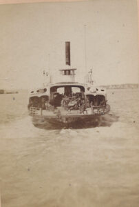
The first involves steamboats. The Pennsylvania native, Robert Fulton, travels to Europe in 1788 to further his dual careers as an artist and inventor, and becomes fascinated by the potential of steamboats to transform water travel in America by going upstream at speeds unimaginable to rowboats or canoes. While in England, he also works with the navy to build torpedoes and even submarines, designed to combat invasion threats from Napoleon’s French fleet.
At the same time, another American, John Fitch, is making trial runs with early steamboat models on the Delaware River. But it is Fulton who builds the first commercially viable steamboat, named The Clermont, which in 1807 ferries passengers over 150 miles from NYC to Albany in some 32 hours.
Soon thereafter, the young entrepreneur, Cornelius Vanderbilt, begins to add steamboats to his fleet, and by 1838 his fabulously profitable Staten Island Ferry is transporting passengers to most points within Long Island Sound. His nickname becomes “Commodore” Vanderbilt.
In 1837 the Western Transportation Line offers a range of steamboat trip between Philadelphia and St. Louis, some 1750 miles and 14 days away. Food is served onboard at a price of 37.5 cents per meal.
East-West Steamboat Travel In 1837
| Philadelphia To: | Price | Travel Days |
| Pittsburg | $6.00 | 6.5 days |
| Cincinnati | 8.50 | 8.5 |
| Louisville | 9.00 | 9.5 |
| St Louis | 13.00 | 14.0 |
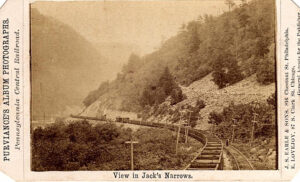
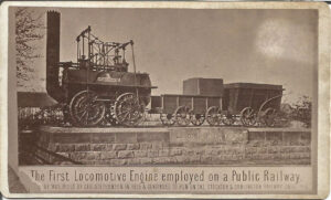
Meanwhile Watt’s steam engine has also been adapted to overland travel, in the form of locomotives. The first one is built by the Englishman, Richard Trevithick, in 1804, for travel on roadways.
By 1825, however, one George Stephenson establishes the Stockton & Darlington Railway, in northeast England, the first public steam train set up to run on iron tracks.
The notion of developing a similar system in America begins to take serious shape on April 24, 1827, when the B&O Rail Road Company is incorporated, to construct a common carrier line linking the port city of Baltimore to cities along the Ohio River, in competition with the seven year old Erie Canal. In 1830, the inventor and entrepreneur, Peter Cooper, builds the locomotive, Tom Thumb, to convince the B&O owners to use his steam engines on their lines.
Within a decade its successor is capable of hauling 50 tons at a speed of 15mph, twice that of a horse-drawn stagecoach. Profits from Cooper’s engine fuels his subsequent investments in iron mills, New York city real estate, and the American Telegraph Company (after Samuel Morse’s 1837 invention), making him one of the richest men in America. He is also a devout Christian who fights against slavery and for Indian rights, and runs for President in 1876, at age 85, on the Greenback Party ticket.
In 1831 Holmes Hinkley and his partner Daniel Child found The Boston Machine Works, which builds locomotives for America over the next three decades. One example is the locomotive “Muzzey,” a 4-4-0 configuration (4 leading wheels, 4 driving wheels, 0 trailing wheels), which they complete around 1854. Businesses see the benefits of rail transportation right away, and the race is on to lay track, especially across the industrializing northern states.
Total Miles Of Railroad Track By Region
| Region | States | 1830 | 1840 |
| New England | Me,NH,Vt,Ma,RI,Ct | 30 | 513 |
| Remaining North | Del,NY,NJ,Md,DC,Oh,Mi,Ind | — | 1,484 |
| West | Il,Ia,Wis,Minn,MO | — | — |
| Border/South | Va,NC,SC,Ga,Fla,Al,Ms,Ky,TN,La | 10 | 758 |
| Total U.S. | 40 | 2,755 |
Taken together, the improvements in transportation enable towns and cities to grow, commerce to boom and new western states to become full, integrated partners in the national Union.